THE SUMMER SOLSTICE SUNSET
The coordinates for the centre of the Newport Tower are: 41-deg, 29' 08.92" N, 71-deg 18' 35.62 W.
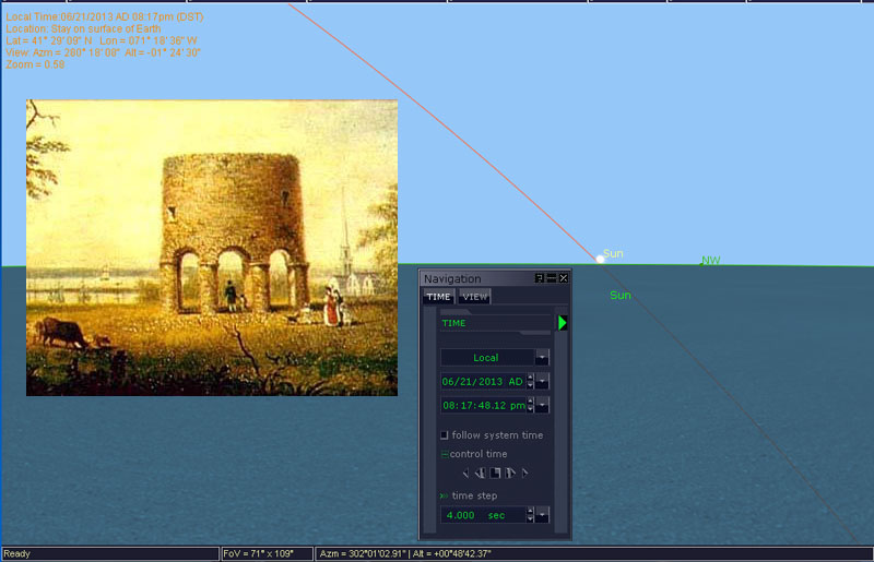
When these coordinates are placed into the astronomy program, Red Shift and the slightly elevated horizon line above sea level, where the Sun will be seen to alight on Windmill Hill, is taken into consideration, then it seems to confirm what is recorded in the literature; that the landing azimuth of the summer solstice Sun is at 302-degrees. With the Sun coming down at a steep angle towards the North and sinking into mother-earth, the "last-glint" could be fixed at about 302.4 or 302.5-degrees.

An early era painting shows that the Newport Tower once had long distance, unobstructed views westwards across the harbour to the Summer Solstice set position on Windmill Hill. The terrain throughout the region is reasonably flat (no really high hills or mountains) and both the position of the tower and the summit of Windmill hill were of approximate equal elevation (circa 85' above see level). To this was added the 28' of tower height, giving it the loftier advantage.
It seems very doubtful that the choice of a spot to build the tower, where it would align onto a summer solstice sunset azimuth angle of 302 to 302.5 degrees could be a simple, unplanned coincidence. Other spots could have been chosen which, because of differing elevations in terrain, would cause the solstice sunset to significantly undershoot or overshoot the 302-degree alighting position.
In very ancient times, the numerical values of 3024' & 3025' were highly revered and knowledge of their significance opened up the possibility of safe traversals of the world's oceans and successful navigation. Each value represented 1/2 of 1 minute of equatorial arc within two slightly differing navigational methods that used miles of 5250' and 5280' respectively.
One perimeter circuit of the Great Pyramid of Egypt was literally 3024', but could be symbolically read as 3025'. The values 302.4 or 302.5 would each constitute 1/20th of 1-minute of equatorial arc, or 3 seconds of arc, under two slightly variable navigational systems.
As is encoded into the due North distance from the tower to the crown of Miantonomi Hill (9072' ... or 3 X 3024') the azimuth angle to the summer solstice sunset deliberately sets out to accentuate the methodologies in vogue during remote antiquity for calculating the equatorial circumference of the Earth, as well as the two most common mathematical systems for accomplishing accurate positional plotting at sea.
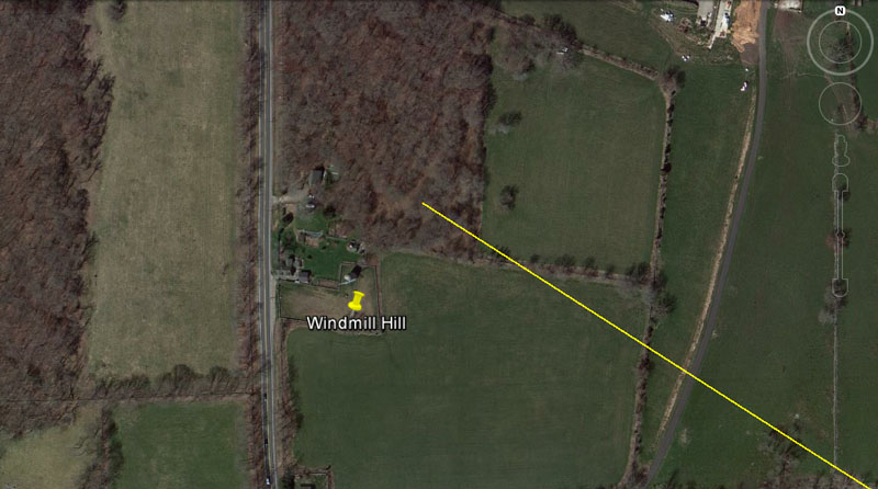
A yellow line extends from the Newport Tower for 20625' @ an angle of 302.4-degrees and resolves upon the highest position of the hill. The point of resolution should coincide very favourably with "last glint" of the sinking summer solstice Sun, as observed from atop the Newport Tower.
So, what significance could this distance (20625') have?
William Flinders Petrie and others investigating the pyramid structures of Egypt detected 3 very slightly different Royal Cubits in use, some of which are actual artefacts on display in our museums.
Although archaeologists contend that these rules were used to build edifices, any modern-day carpenter, looking at the way the cubits are divided up into uneven segments, would quickly conclude that they would quite useless in that regard, so they must have had some other function.

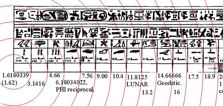
The segments of an Egyptian Royal Cubit of 20.618-inches in overall length (as displayed at the Turin museum).
The 1st interval is a PHI inch (1-inch X 1.6180339);
The 2nd interval is a PI-inch (1-inch X 3.1416);
The 3rd interval seems to be coded at 4.6656-inches (navigational progression);
The 4th interval is a special PHI reciprocal value that was absolutely essential for the fabrication of correct (precise capacity) round volume vessels for the ancient market places... for example: the ancient British Bushel was a round tub with a base diameter of 3 X 6.18034-inches and straight sides above the base 8-inches high, giving an exact capacity of 2160-cubic inches);
The 5th interval is navigational (note: the Great Pyramid is 756-feet long);
The 6th interval codes 9 or 9.072 and is navigational;
The 7th interval codes 10.368 (the 24883.2 circumference Earth rotates at 1036.8 MPH);
The 8th interval relates to 4 lunar months or 118.125-days;
The 9th interval relates to navigation by the mile of 5280' (1/4th of a mile is 1320');
The 10th interval relates to navigation by the "11" family of numbers;
The 11th interval relates to navigation by the "6&7" family of numbers;
The 12th interval relates to the equatorial circumference of the Earth under the Great Pyramid's literal base dimensions (each side is 189' X 4), etc.
The Royal Cubit layout was, as stated, unsuitable as a rule used in building work, but functioned more as a specialised calculator and memory device. Other, more factorable, cubit or foot rules would have been used in construction work.
The 3 main Egyptian Royal Cubits, in their overall lengths acted as mnemonic devices for remembering the equatorial circumference of the Earth and these selfsame cubits were used for this function by many early and latter civilisations.
Therefore, the distance from Newport Tower to Windmill Hill would have been (by triangulation mathematics) configured to be 12000 Egyptian Royal Cubits (literally and in a tutorial sense, with inclusion of all 3 types for teaching purposes).
It is fast becoming apparent that the mathematical systems encoded into the position of the Newport Tower, in relation to its outer-markers, are steeped in age, using mathematical systems that had been all but forgotten by the dawn of the North American colonial era. This parcel of very ancient cyclic-astronomical and navigational numbers had widespread use in antiquity and was taught by Continental European and Mediterranean civilisations in pre-Christian epochs, but later came under violent assault from the ever more menacing church, which drove the numbers and the guilds that cherished them underground to become, "secret societies" harbouring so-called occult knowledge.
The possibility that the Newport Tower is pre-Columbian is looking more and more likely as we delve deeper into the numbers it generates.
THE WINTER SOLSTICE SUNSET
From an unobstructed vantage point atop the Newport Tower, the Winter solstice Sun should have once been detected to alight onto, what is now, the Point Judith Road ridge @ very close to 237.6-degrees azimuth. This spot sits just South of the Point Judith Country Club and, at around 100' high, is the most elevated position in the direction out to the Winter solstice sunset.
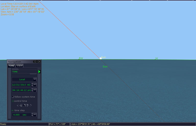
Red Shift astronomy program indicates that the Winter solstice sunset alighting position will be very close to 237.6-degrees azimuth.
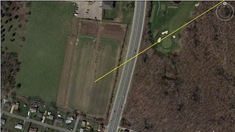
A yellow line is seen to extend for 55000' (10,000 ancient English merchant seaman fathoms of 5.5' each) from the Newport Tower to the western side of Point Judith Road on the elevated ridge, traversing Point Judith Country Club en route. The azimuth angle is set at 237.6-degrees and should coincide respectably with the alighting position of the Winter solstice Sun.
It seems obligatory that, at the Newport Tower observatory, the ancient navigational value of 237.6 would have featured as a tutorial to initiate astronomer-navigators by this number's association to the Winter solstice sunset position.
The ancient Scottish mile (5940') was 1-furlong longer (660') than the English mile (5280') and 2376' X 2.5 = 5940'.
In the 24750 English mile equatorial circumference of the Earth (130680000') this distance across the bay from the centre of the Newport Tower to the observable Winter solstice alighting position (55000') would be a 1/2376th division.
The return angle from this sunset position to the Newport Tower was 57.6-degrees and this is yet another dynamic value from the ancient parcel of factorable, cyclic astronomical and navigational numbers.
For example, the distance covered in 1-minute of equatorial arc is 6048' or 576 ancient reeds of 10.5' each (126" or 10 Greek feet).
In the 12 X 12 X 12 X 12 X 1.2 - mile equatorial circumference (24883.2-miles) the distance of 57.6-miles would be 1/432nd part.
The Greek mile (5250') was related to a subdivision called a "stadia" (630')
and there were 576 stadia in 1-degree of equatorial arc (362880') or 207360*
stadia for one full circumnavigation of the Earth's equator (360 degrees of
arc travel).
*Note: the largest of the 3 Egyptian Royal Cubits was 20.736".
In the 6804-day lunar nutation cycle there would be 57.6 intervals of 4 lunar months each (118.125-days), etc.
In an age where there were few books or scrolls, lessons were learnt by rote and repetition and the memorising of mathematical progression sequences. The sciences were encoded in numbers and those selfsame numbers were expressed in all weights, measures and volume standards used by ancient civilisations.
Similarly, the long range to the West, extending from the Summer solstice to the Winter solstice positions, would have offered an excellent fix point in the mid-range onto the vernal and autumnal equinox sunset positions (almost due West).
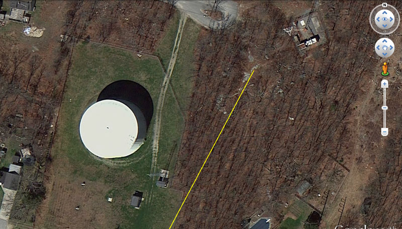
A line extending from the Newport Tower @ 28-degrees azimuth for 13.125-miles, resolves upon stonework atop Pocasset Hill (320'), at Tiverton, the highest point in Newport County.

Stonework adorns the summit of Pocasset Hill and some of these obelisks might once have acted as outer trig markers. It remains to be verified if any of these were purpose-placed stones, relating back by coded distances and angles to the Newport Tower, with yet others indicating orientations to other high trig points further afield. It would seem plausible to assume that this highest of local hills would have been exploited as a regional mapping position.
The recumbent stones in the photograph certainly seem to display the typical "sharks-fin" shape (wide base and more pointed top) that this author has seen on many ancient standing stone circle sites. Geologists would be able to quickly conclude if these obelisks occurred naturally at these positions of the summit or were purpose-placed by some ancient society to fulfil a special surveying function.
The azimuth angle of 28-degrees to this summit position carries ancient Sabbatical Calendar coding in the number it generates, just as the Newport Tower carries the same code in its official height (28').
A mathematical progression based upon this value will generate many highly useful numbers, used copiously in ancient navigational, lunar and calendar calculations.